Tuesday, August 22, 2017

Photographing the Great American Solar Eclipse of 2017


It is a rare situation when you get to gaze at an event that has not taken place in the United States for nearly 40 years. This I speak of is the Great American Solar Eclipse that took plays August 21st, 2017. Calling it the Great American Solar Eclipse may seem a big egotistical of a country to call such a celestial event as to being owned by one country. Well, it is a bit simpler then that, and is more of a matter of pride. Not that other countries have not had the same opportunity, but quite simply this event creates a few 1st times.

  • This is the 1st time since 1979 that a Total Solar Eclipse has been visible int he United States.
  • This is the 1st time since 1918 that a Total Solar Eclipse has been visible Coast to Coast in the United States.
  • This is the 1st time in recorded history that a Total Solar Eclipse has been visible in a single country only.
The next total eclipse to be visible in the United States will be in 2024.

April 8, 2024

Lasting a maximum of 4 minutes, 28 seconds, this is the next major total eclipse that will hit North America.

The path of totality first hits Mexico in Mazatlán, followed by Durango, Torreón and Piedras Negras. In the US, the path of totality will pass over:

  • San Antonio and Dallas
  • Little Rock, Arkansas
  • Indianapolis
  • Dayton, Toledo and Cleveland, Ohio
  • Erie, Pennsylvania
  • Buffalo and Rochester, New York
  • Montpelier, Vermont
  • Caribou, Maine


With that said, I had the opportunity to venture to the West coast to view this years Eclipse. I chose not to travel north to the path of totality due to fuel cost, as stations were raising them, as well as traffic. None the less I was able to capture some "stellar" shots out of Mt. Shasta, CA.


Set up and prepared
 Arriving early at the Shastice Park, I set up my gear. My tools for this celestial event included a tripod with a video/photo rig mounted on top if, with a Canon XSi atop it. Fasten to the front was a 300mm zoom lens. While my solar protection for the lens began as a auto adjusting Welder's Mask, a nearby observer having brought a few viewing filters, gave me one in exchange for later emailing her images.


Photograph to calibrate settings
photo by Errol Jud Coder

As the eclipse approached is transit, predicted to be at 9:03am PST, the park began to fill. An event tent with donated mimosas, moon pies and sun chips was erected and serving people on the other end of the park. But, I kept my location, free of the crowd. Despite that fact, I still attacked people around to look at my rig anyways. Guess its to be expected. 

To take photos of an object through a filter that completely blackens out everything around, but the sun is quite tricky. The settings have to be done just right to counter balance the extreme loss of light with the extreme brightness of the sun itself. It is because of the intensity of the sun that people were warned not to look through filters not designed for solar viewing, or through goggles/welder's masks of #14 darkness or darker. If done for too long, the light would fry camera sensors, and cause damage to people's eyes. So in having the appropriate equipment I made adjustments using the sun itself. My initial settings were f8.0 and 1/100th at 400 ISO.

At precisely the predicted time, the moon began to drift across the top right corner of the sun. Little by little it took bits out of the sun as if it was a wheel of cheese being chewed on by a hungry mouse. As the moon passed from the top right to bottom left, you could see the section on the right side that was left uncovered. It is this portion, nearly 10% that would have been covered were I in the path of totality, some 350 miles to the north. A

As the moon transitioned across the sun, I had to make minor adjustments as less light came through. As I made my changes over the hour, the sun continued it's path
Full Eclipse Progression
photo by Errol Jud Coder


Monday, July 4, 2016

Great views of Saturn System - Jun 2nd - July 2nd, 2016

Some great imaging was received by the Cassini space craft between Jun 4th and June 12th as it Orbited Saturn. Saturn, using is wide and narrow angle cameras captured great detail of Saturn's surface, rings, and Moons Titan and Rhea.

Image Credit: NASA/JPL-Caltech/Space Science Institute
On June 2nd, while turning to face it's moon Rhea, Cassini captured this image of the atmosphere of Saturn, including its northern polar region. This is using the CB2 and CL2 filters

Image Credit: NASA/JPL-Caltech/Space Science Institute
On June 3rd, angled its narrow angle camera towards its moon Rhea using its P0 and UV3 filters. It is illuminated as a full sunlit disk revealing its prominent craters. As you can see, it is much like our own moon.

Image Credit: NASA/JPL-Caltech/Space Science Institute
On June 4th, Cassini aimed it's narrow angle camera at Saturn's largest moon capturing this image with its CL1 and CB3 filters, Titan. Titan is covered with a methane case. You can see the atmosphere layer. The darker regions are surface features seen through the cloud layer.


Image Credit: NASA/JPL-Caltech/Space Science Institute
And finally, as it has swung around from its view on Titan, Cassini captured Saturn in all it's glory as it faces directly at Saturn, swooping down below its southern pole. The rights are very prominent in this image. Cassini at this time has passed the plane of its rings going from above the rings, capturing images, then passed below the rings looking out the south pole This is using its  CL1 and Infrared 1 filters

Image Credit: NASA/JPL-Caltech/Space Science Institute

As Cassini heads back north passed the plane of its rings again, it looks down at the rings on July 2nd. Top right of the screen you can see the white dot, that appears to be one of Saturns moons inside the inner ring.

Sunday, February 14, 2016

Sol 1249: Curiosity Rover Panorama at Namib Dune

Image Credit: NASA/JPL-Caltech/MSSS/composite by Errol Jud Coder
click image to enlarge
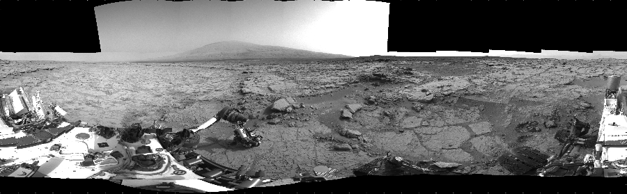
Mars Science Labatory (MSL) or more commonly referred to as "Curiosity" has continued her trek along the surface of Gale Crater on Mars, as she continues en-route for climbing Mt. Sharp.

This is a 5 image composite panorama, captured by the color imaging system of the Narrow Angle Mastcam on Curiosity from Sol 1249 on February 10th, 2016. Upon close examination it shows curiosity is on a rise with a lower field with in the crater beyond. You can see the variation in the different geological structures found on the surface, from scrapes, gullies small rocks, and in the distance, the rising edge of the crater rim itself.

Friday, September 19, 2014

67P/C-G-How to measure comet geological structures using shadows

While composing the various images of comet 67P/C-G, I noticed a number of sharply angled structures that when viewing their shadows, appeared to be much more jagged and higher then appeared. It came to me how interesting how it might be to understand the scale of many of the objects and structures of craters and mounds that we generally either see overhead or at an angle as observed from the Rosetta orbiter.

To measure distance of an object you cant directly measure, like on Earth when seen from orbit, you need a couple pieces of information. Using trigonometry, the phase angle of the sun, and the known distance in pixels of an image, this can happen. After requesting it on the Sep 11 composite post on the ESA Rosetta forums, the first inclusion of the phase angle "angle the sun is pointing at the comet" was included in the Sep 14 image post.

To show you how this works, I am using the Sep 14 composite image I stitched together from the three images captured by Rosetta.

So, what are our initial measurements?

We are told that the phase angle is 61.5 degrees
We are observing 2.5 meters per pixel. It is roughly .400m/pixel

We now need to determine the sun's azimuth. Making up North on the image. Measuring the angle of the shadow to the E/W line, it can be determined the azimuth to be 270 degrees.


How do we apply all this information to determine depth/height?

1. First measure the distance from the top of a feature, to the end of the shadow.

This feature is measured at 67.7 pixels. If you multiply it by 2.5m/pix, you arrive at a distance from top of feature to end of shadow as 169.25m.

2. Now plug in the numbers to the equation.

d=169.25m*tan(61.5degrees)
d=308.5
d=309m

If we then apply the same method to the little hill to the upper right of this formation we get a height of 107m.

Now using this method, knowing the phase angle of 61.5 degrees, and measuring the pixel distance you can determine the estimated depth of craters and height of features. As long as the Rosetta forum mods include the phase angle in each of their image submissions, this can be done.

Friday, September 12, 2014

Cassini capturing storm on Saturn

NASA/JPL/Space Science Institute/Errol Coder
Captured at approximately 1,624,665 miles (2,614,645 kilometers) away from Saturn, this image composed of 3 other images using the MT2, CB2, and IR filters of the Cassini orbiter, this image seen in false color details the different cloud structures of the Atmosphere. The  cloud walls are clearly visible rotating around the central storm that resembles the one on Jupiter a great deal.

Comet 67P/C-G - Possible evidense of dust vent?

click image to enlarge
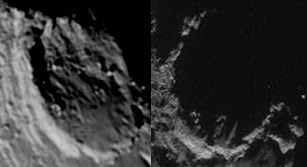
On August 17, 2014 the left image was captured. What appears to be a discoloration or shadowing in the crater stretching across a number of different boulders seems to no longer appear on the new image captured on September 10, 2014. The Sep 10 image doesn't seem to show any ridge or anything that may have caused this line of darkness. I attempted to color code a version of the above image to pinpoint which lines were in line, but it was a no go. Too many differences in stone orientation.

I wonder if this could perhaps be evidence of some sort of linear vent? The area along the line in the Aug 17 images appears rougher and more stones seems to be along the discoloration. Yet, when we see it again in the Sep 10 image, the area seems to be a lot more smoother, perhaps the smaller stones/boulders having been covered by the dust? Though, is there enough of a centripetal force for dust to settle?

Additionally, in the lower left of the right image, there does appear to be a round O shaped feature like a "Cheerio." The way the shadowing is seems to appear it has a pit veres the top or jagged edge of another boulder. Could this also be a vent? It does also seem to be there on the left as of the "Aug 17" image.

Update 1 - Sep 12
I rewatched the arrival conference video. http://wpc.50e6.edgecastcdn.net/8050E6/mmedia-http/download/public/videos/2014/08/010/1408_010_AR_EN.mp4

When they approached the comet and was testing out VIRTIS, they detected that the minimum mean temperature of the comet seems to be coming from the neck. We must then ask, why? We have seen images of direct sunlight, and it was getting direct sunlight at the time of the measurement. The max temperature came from a section on the "Body", the mid temp was on the "head", and minimum on the neck. The areas void of volatiles and are pores are the locations with the max temp. Does this mean there is either more volatiles and the area is less pores at the neck?

 The Sep 2 image did show out gassing at the neck, which would seem to make sense if there were more volatiles there.

We also saw jets at the plains area on the underside of the "body". Im interested in measurements there, and at the large plains area on the crown of the "head" as seen in my comparison. It would seem due to the smoothness that there has been activity there.

Now, since they did post the VIRTIS map on the 8th. It does show that the top of the "head" which is A site landing target is very cool, so is the area around the neck, as well as the bottom of the "body" as very cool. The large plains on the body which Bill and I had recently conducted comparisons is also the other cool location.
http://celestialimaging.blogspot.com/2014/09/67pc-g-comparing-shadows-and-angles.html

These three locations seem to show the evidence of activity geologically. While these areas would be great landing sites terrain wise, they are areas of cold conditions. The only one of these where a landing was considered was "A", which may have lost out due to the revelation of the temperature. The landing sites seem to be in areas other then these active locations, which for a success of the mission, would make sense, though the question stands, will there be any data regarding the outgassing if you are not in an area not as active? Come November perhaps those sides of the body will be more active. But, as they are the hot areas, it would show that not only is it porous there, but either low or no volatiles. Which goes to show, IF there are volatiles at the dark regions, what do they composed of? We wont get this answer unless we are there to drill and find out.

Possible Landing Site "A" on the crown of the "head"
http://celestialimaging.blogspot.com/2014/09/comet-67pc-g-has-ridge-gone-missing.html

Update 2 - Sep 12
After further research,

The line/discoloration is visible on the arrival images as showing during the arrival webcast. To orientate you, he image compared to the above images are upside down.The O cheerio stucture is now seen at the upper right of the image now.


Wednesday, September 10, 2014

Cassini image composite of Saturn's North Pole

Image Credit: NASA/JPL/Space Science Institute/Errol Coder
Traveling at a distance of approximately 1,699,200 miles (2,734,597 kilometers) away from Saturn, the Cassini orbiter captured a sequence of images focused at an angle above Saturn down towards it northern pole. Using its CB2/IRPO, CB3/IRPO, and MT3(Methane)/IRPO filters, I combined the three images into a false color image. The false color, while not true colors, allows the viewer to see the different divisions, features, and differences between the different characteristics of Saturn.

Tuesday, September 9, 2014

67P/C-G Comparing Shadows and Angles from Aug 15 and Sep 7

The time of day and angle of an image in photography can play a tricky part in the process of imaging. It can also reveal important information about a subject. Capturing images at different times of day which results in different shadow angles, as well as capturing them at slightly different angles changes the image significantly. The same goes for the Rosetta orbiter as it captures its images of comet 67P/C-G.

On August 15, 2014 an image of the comet that appears to be the end of the section typically designated as the "body." The sun was at an angle nearly straight on causing short shadowing on the surface. Only in areas with high crater walls were the effects of the shadows drastically present. A part of the comet typically called the "head" of the comet is seen in the distance past the "body" section on the left side of the lower left of the image.

But, then today Rosetta again captured an image of the same area, but the sun itself was at a drastically different angle. This caused some interesting shadowing and made some areas that originally looked smoother, to appear rougher and more jagged. Additionally, due to the angle of illumination the "head" section that was visible on the August 15 image was now hidden.
 
Some interesting observations can be taken from these two slightly different images.

#1. On the Aug 15 image, the 8 boulders that are present in the oblong crater appeared to be low to the surface with broader structures. But, in the Sep 7 image made them appear to be taller then expected. While the field of view (FOV) of the NAVCAM is slightly more over head, their shadows just light with the local peaks of the craters are quite long. Although, their shapes seem to indicate the rocks to be a bit less round at their tops. While the shadows do elongate the shape of the object, they do help aid in identifying their basic shape. In fact one, the lower left of the right three boulders appear to be more wedge shaped.

#2. The crater on Aug 15 appears to have a shallower depression. While the crater wall on the left shows shadowing, the remaining area of the crater doesn't appear to be much lower. But, when you compare it to the Sep 7 image, a few things stick out. A few features on the lower section of the crater while appear smooth, indicate three raised ridges. Additionally, a single ridge on the upper left of the crater on Sep 7 shows a wall high enough to cut through the edge of the crater, and high enough to capture an illuminated slope on the sunward side cutting through shadowed crater floor.

#3.Yet again, areas that while are on the edge and would begin to wrap around the edge of the comet, seem to appear more level ground. But, due to the angle of the shadowing, crater edging seems to appear as the image wraps around the side.

#4. Using a bit of trigonometry by knowing the angle of the sun to the object, and knowing some bit of measurements such as the length of the shadow itself, you may be able to calculate the height of a peak from a crater. But, some of that information may not be available. If someone with a bit more trig experience wants to give it a go, I think it would be possible with a bit of digging for angle and distance numbers to find its height. What is interesting is the drastic change between the length of the Sep 7 peak (left) on the left and the peak shadow on the right as well as the second step the appears nearly halfway down the slope. Now, as the area of illumination on the side of the formation side seems to be relatively the same amount of area on both days, the height may be quite shorter, relatively then observed. But as we are looking nearly straight down it would be hard to really visualize the the height. But, as observed, the shadow on Sep 7 seems to give hint to the real topography of the area.

#5. Just like with #4, a lack of shadowing can be deceiving in regards to land structure. Apparently, the edge of this crater/field is higher then originally observed, as it casts a quite uneven edge shadow hinting at the structure of this edge. What is quite interesting is the deep in the middle showing two tall peaks that are completely invisible in the Aug 15 (left) image.

#6. While it may simple be a visual illusion, there seems to be a boulder propped on the edge of the hill/crater edge. You can see it in the Aug 15 image both on the top of the wall, and rising higher then the top of the rim in the shadow. The shape and protrusion with a squarish top to it would seem to be an independent object from the shape of the rim edge itself.

#7. This section of the crater field may give indication to the comet activity. It doesn't seem to give the typical signs of showing a crater edge. Although, visually, the right side is the higher smooth ground, while the crater evenly dips down into the other smoother field. My question is, what would make for smooth surface? I would suspect it is similar to what occurs on the moon for the Mare. The Mare are flooded (by volcanic erupted basalt) impact craters. While the interior of the Moon was still hot an molten, asteroid or comets hit the moon and created impact craters. Lava from the Moon's interior then welled up to flood these craters, making the Mare. But, would a comet once have an interior like this? If so, these comet mare would be much older then the surrounding overlaying caters. Instrument investigations indicate that there is very little near surface ice, so these Mare would not seem to be formed by ice. Is this a remnant of the comets ancient hotter period?


#8. Even such a drastic angle of the sun, the "head" of the comet disappears. The only surface that remains is the "body" as its wrapping edge ends at the terminating shadow edge. You would not guess that with just a bit of change in the suns angle that a completely other piece of terrain exist nearby.


Friday, September 5, 2014

30 Days of comet 67P/C-G

Launching in 2004, and traveling for the last 10 years of an estimated 12 year voyage, the Rosetta orbiter has conducted gravity assist after gravity assist flyby maneuvers with the Earth and Mars as it traveled around the sun during its long mission to eventually rendaveau with, orbit around, and land "the Jupiter-family comet 67P/Churyumov-Gerasimenko with a combination of remote sensing and in situ measurements". On August 6th, 2014 it finally arrived at the comet and immediately got to work. As it approached the comet on August 1, 2014 it began a sequence image capture that included a composite animation of 101 of them, using its NAVCAMs (Navigation Cameras) as it continued to approach

On August 6th as it arrived in orbit about the come, it began its Global Mapping of the surface which continued through August and into September. The images, using OSIRIS aboard Rosetta were captured in full from as it slowly orbited closer and closer to the tumbling mass of cosmic collisions. It is observed of course that the comet itself was formed by the collision of two other objects, that connected and fused at the "neck" area of the comet itself which gives it its odd "duck bill look."

Unfortunately, as Rosetta has moved closer to the comet, 50km as of August 23, instead of being able to capture a full frame of the comet, it began capturing only 1/4 segments to still allow for mapping of the object. These new segments were released on September 1st, allowing the image processing community the ability to create composites of a few that had been captured on August 31st. The second of these four-part images were released on September 4th of a sequenced captured on the 2nd.

On the August 31st images, a plume of what appears to be dust or some sort of out-gassing is seen originating from the "neck" narrow section of the comet.

The following animation is a complete sequence of the released full frame images from August 6 to the 23rd, and the composite images I have been splicing together from September 1st through the 4th.

While these images are captured days apart, it is interesting to see how the comet itself continues to tumble about its wobbly rotation.


ESA/Rosetta/NAVCAM/animation by Errol Coder


Thursday, September 4, 2014

Venting captured from comet 67P/C-G

The European Space Agency operates the ROSETTA spacecraft that is currently enroute towards comet 67P/C-G. Due to is close proximity to the comet, the NavCam, which was capturing full frame images of the comet, it now can only capture a smaller field of view. As a result, ESA has put a task out to the imaging community to create composite images of the quarter sections of the comet they release each week.

Their first set of images were released September 4th of the images captured on the 2nd. At a distance of 56kms, four images were captured, approximately 20 minutes apart as the capture changes its angle. The comet is also rotating on its axis at this time. So not only are the images captured minutes apart, but the view of the surface features also change position.

It takes a bit of twisting and adjusting to stitch the four images together to create a cohesive composite of the combined images. But, when done correctly, you can reveal some great features on the surface, and also other interesting occurrences.


This image was combined using the 4-images, stitched together and enhanced to help the features come out. While there are currently clearer composite images completed by other individuals, this image that I processed is targeted to help highlight the current out gassing of the comet itself. Out gassing occurs when parts of the comet, has contact with the direct sunlight, causing the surface to heat up and react with trapped gases beneath the surface in the rock and ice that compose the comet. In this image, it was processed to have  +10 brightness and -12 contrast to reveal the out gassing jet that forms a plume in the "neck" of the dirty snowball. It seems to reach quite a distance, nearly the same distance as the comet is long.

click image to enlarge
To be able to see the more detail on the comet itself, the brightness was reduced -72 from the above settings. While the out-gasing plume is lost, the surface features popout and become more clear.

click image to enlarge

Sunday, August 24, 2014

Close Encounter with Saturn's Moon Titan


Image Credit: NASA/JPL/Space Science Institute/ composite by Errol Coder
On August 21st, 2014, Cassini captured this image as it passed by at approximately 132,693 miles (213,549 kilometers) away from Saturn's largest moon Titan, and the image was taken using it's blue, green, and red filter. The blue glow seen on the northern and southern poles of Titan are infact the visible aspects of its outer atmosphere.

Thursday, May 16, 2013

360 Panorama of Mt. Sharp by Curiosity

NASA/JPL-Caltech
click image to enlarge
NASA's Mars rover Curiosity took 40 images in Gale Crater using its mast-mounted Left Navigation Camera (Navcam) to create this mosaic. The seam-corrected mosaic provides a 360-degree cylindrical projection panorama of the Martian surface centered at 180 degrees azimuth (measured clockwise from north). Curiosity took the images on January 26, 2013, Sols 168-169 of the Mars Science Laboratory mission at drive 0, site number 6. The local mean solar time for the image exposures was from 3 PM to 4 PM. Each Navcam image has a 45 degree field of view.

Titan before Flyby

On May 14, 2013 Cassini captured a series of images of Titan at a distance as it prepares for its flyby on May 23, 2013. This is a False color composite using Cassini's CB3, MT3 (methane), and UV3 (ultra-violet)  filters. You can clearly see the methane atmosphere, and the collection of the green hue at Titan's northern pole. Using the CB3 filter, it allows us a glimpse through Titan's thick atmosphere, and see aspects of the surface.

NASA/JPL-Caltech/Space Science Institute/composite by Errol Coder
click image to enlarge

Monday, March 4, 2013

Color Contrast of Saturn

click image to enlarge
On February 28, 2013 on its way to a flyby of Saturn's moon Rhea, Cassini captured images of the face Saturn using its Continuum band 2 and Methane band 2 filters. This is a two image composite of those two shots. Using the methane filter you can see the detail in the swirling gas layers that you would often see at Jupiter. This is a false image of the atmosphere of Saturn to help show the distinctive differences in the coloration and to bring out the details in the methane gases. The planet is tilted so the top is at the top left.


NASA/JPL-Caltech/Malin Space Science Systems/ composite by Errol Coder
click image to enlarge

Monday, February 18, 2013

Curiosity Rover: Beautiful Mars Panorama

Image Credit: NASA/JPL-Caltech/Malin Space Science Systems/ composite by Errol Coder
click image to enlarge
On February 15, the Curiosity Rover (MSL) captured this Panorama of its current investigation location. This imaged was spliced together using 18 panoramic images captured by the Left Mast Cam on board the Mars Science Laboratory. In this image the filters have already been applied and color corrected on board the rover itself before being transmitted back to Earth. This view stretches from the NE at the edge of Mount Sharp to the NW along the crater rim.

Sunday, February 17, 2013

Titan Flyby: Eclipsed

Credit: NASA / JPL / SSI / composite by Errol Coder
click image to enlarge

 
The first images from Cassini are coming in from the flyby on February 16. These first images were taken approximately 173,902 miles (279,868 kilometers) away using the RED, GRN, BLU filters. It is the Methane filters that typically bring out the detail in atmosphere and surface. As Cassini flies by hopefully we will see those filters used to help bring out the detail. But,we can see right now is the Methane atmosphere coming in as blue along the edge of Saturn's larges moon. Once the new images are received, I will be processing them and posting. Look forward to some gorgeous images!

Saturn's Rings in all its Detail

Credit: NASA / JPL / SSI
Many of the images I process are captured using many of the filters that the Cassini has aboard. These images can be layered for the particular connected RGB colors, to bring forth some brilliant shots. This image is different. This is the original high res image captured on February 15th. This set of images were taken with the clear filters. Simply put, it is beautiful in itself. you can see great detail the separations in the rings.

The A-Ring is to the right of the Cassini Division, which is the separation you see to the ride side of the image with the B-Ring to the left of it.

Friday, February 15, 2013

Color Composite of Saturn's outer rings

Credit: NASA / JPL / SSI / composite by Errol Coder
On February 13, 2013 the Cassini spacecraft completed a flyby of Saturn's rings capturing a long series of images as it passed above it. In this image, using the RED, BLU, and GRN color filters a false color of the image was formed to show the detail int he different rings. The outer F-Ring (white) can be clearly seen with the large divide between it and the A-Ring.

Friday, August 24, 2012

Curiosity's first drive on Mars

This image was taken by Rear Hazcam: Left A (RHAZ_LEFT_A) onboard
NASA's Mars rover Curiosity on Sol 16 (2012-08-22 14:25:05 UTC)
Image Credit: NASA/JPL-Caltech
click image to enlarge
On Sol 16, August 22, 2012 the Curiosity rover took its first short drive and made its first tracks on Mars in Gale Crater. This activity was to check out the roving functionality of the wheels prior to its long drive to Glenelg. It would appear that Curiosity has started to accumulate dust on its Left Rear Hazcam.

Monday, August 20, 2012

MER Opportunity Rover on the edge of Endeavour

After Opportunity's stay on Greeley Haven it had recently taken a short drive around the northern edge of Cape York and traversed across "Whim Creek" on Sol 3010. After reaching the northern tip of Cape York she continued around to its present position on August 20 "Sol 3048", just past the creek.

Image Credit: NASA/JPL-Caltech/Cornell/Arizona State U/composite by Errol Coder
click image to enlarge
These most recent images captured by the Pancam on Sol 3044 is a 6 image composite that points into Endeavour Crater showing the rim in the distance.

Image Credit: NASA/JPL-Caltech/Cornell/Arizona State U
click image to enlarge
This 2 image composite also using the Pancam shows a dimple and stone outcropping next to the Opportunity rover.

Image Credit: NASA/JPL-Caltech/Cornell/Arizona State U
Traverse Map as of Sol 3044
click image to enlarge